

It’s the time of the year again when you feel like the mountains are calling you for an adventurous hike. The USA has the most exciting trails that offer breathtaking views that are indeed food for your eyes. This article lists the top 15 best hikes in the US, ranking them from the hardest trails up to the easiest ones for hikers of beginner, intermediate, or advanced level.
1. John Muir Trail, California

John Muir Trail in California is a legendary 210-mile trek beginning at the Yosemite National Park and traveling 210 miles along with the High Sierra mountain range. The hike is one for the books as you will be welcomed with thrilling views along with steep passes, alpine meadows, lakes, and sequoias.
The hike also gives access to the most beautiful section of the Pacific Crest Trail. Enjoy exceptional views of endless peaks, gorgeous sunrise, and sunset, and have an amazing stargazing experience in some of the best backcountry campsites.
You’ll experience a mild and sunny climate at John Muir Trail, which is great to visit between July and October, avoiding the snow seasons.
The trail route starts with Half Dome and Vernal Falls sights, crossing the Ansel Adams Wilderness and John Muir Wilderness. It is then followed by passing along Sequoia National Park, King’s Canyon National Parks, and going to the highest peak in the continental US, Mount Whitney.
Mount Whitney is nearly 46,000 feet of elevation, crossing six high elevation mountain passes.
John Muir Trail made it to our top list of the most difficult hikes in the US. It is a very tough trail because of the terrain and length of the trail, passing over 11 mountain passes. It would take up to three weeks to complete the hike and is highly recommended for fit and experienced hikers only.
This is a seriously hard trail to finish, so you should know your limits.
2. Appalachian Trail, Shenandoah National Park
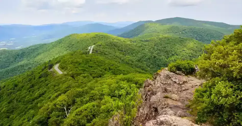
The Appalachian Trail stretches from Maine to Georgia with 2,100 miles covering 14 states. The 101-mile trail portion in Shenandoah National Park is considered a bucket-list trail, crossing Skyline Drive multiple times.
It is easy to find a spot to hike in this trail as it works as a circuit, connecting to other popular routes like Mary’s Rock Summit trail and Bearfence Mountain. The Appalachian Trail takes you on a journey to the heart of the Blue Ridge Mountains, where you will experience the park’s wilderness, from foliage to animals.
You have free access to this wonderful trail all year round. The park’s highest peak exhibits peregrine falcon restoration efforts and magnificent waterfalls. There are many woodlands, river valleys, and meadows along the trail, and if you are lucky enough, you’ll maybe get a glimpse of black bears foraging.
The trail is rated as difficult, which you can finish in seven to eleven days.
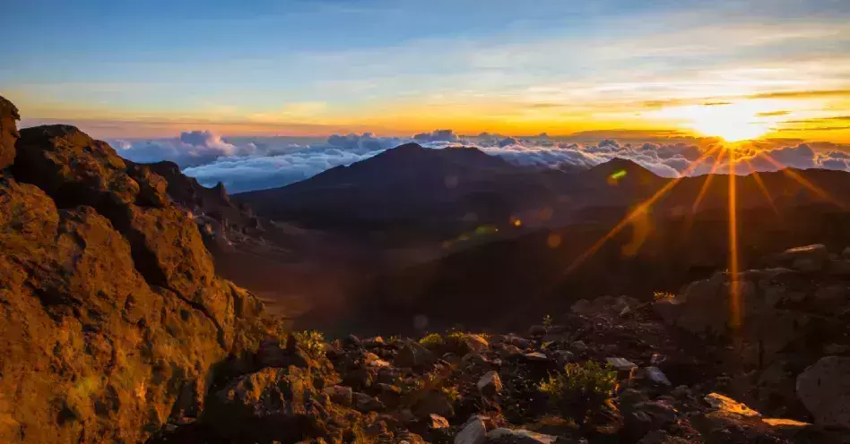
3. Haleakalā National Park, Hawaii
Haleakalā National Park in Hawaii has over 30 miles of hiking trails featuring seven different trails to choose from. Pa Ka’oao is a five-minute, 0.4 miles trail starting from the Visitors Center parking lot.
Leleiwi Overlook is a 0.5 miles trail with a smaller crowd and is usually warmer than other trails. Hosmer’s Grove Natural Trail is another amazing hike with the same length at the park’s lower boundary. It loops around a dense grove of trees and features sweet-smelling pine and fir, 20 plus species of trees, and forest birds fleeting around the treetops.
A longer hike at the well-defined Halemau’u Trail features a 7.5 miles hike beginning at an altitude of 7,990 feet and gives you a view down the Ko’olau Gap. The three remaining trails are Keinehe’ehe’e Trail (8 miles hike), Sliding Sands-Switchback Loop (12.2 miles hike), and the Kaupo Gap.
Kaupo Gap is the most legendary hike in Haleakalā Crater. It is a two-day trip that features over 17.5 miles hike.
Haleakalā National Park offers many attractions aside from its magnificent trails like the breathtaking sunsets and sunrises, dense rainforests, mountain valleys, and volcanic landscapes. It is a unique national park with at least five separate climate zones.
Trails in this park are rated difficult because the high elevation serves strenuous trails around the Summit Area. There is a lower concentration of oxygen, making it harder to breathe in each step and causing altitude sickness to some hikers.
The temperature as the hike progresses is 30 to 65 degrees Fahrenheit or -1 to +18 degrees Celsius.
4. Kalalau Trail, Hawaii
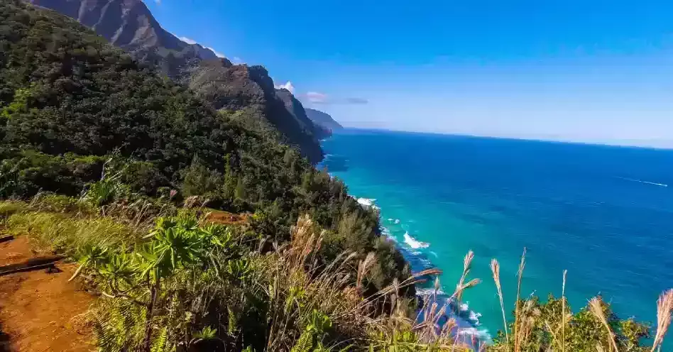
One known adventurous hiking trail in Hawaii is the Kalalau Trail. Its trailhead is located at the Hāʻena State Park at the northwest end of Kūhiō Highway (Route 56). The 11-mile trail travels across five valleys, crossing above towering sea cliffs, ending at Kalalau Beach, which drops at sea level at Hanakapiai Beach and Kalalau.
The trail serves as one of the only ways to access Napali Coast via land and would take a full day to finish for most hikers in good condition.
The first two miles of the trail are popular for day hikes, starting from Hāʻena State Park to Hanakapiai Beach. Going beyond Hanakapiai valley would require a valid overnight permit, and the trail from Hanakapiai falls and beyond is only recommended for experienced hikers.
Nearshore swimming is a known activity for experienced swimmers on this trail. You must be knowledgeable about local sea conditions. There is only a limited opportunity for swimming and body surfing. Due to extreme rip currents and wave patterns, water activities are not recommended at the Hanakapiai beach.
Other natural sights you may expect in Kalalau Trail are native tropical plant species, numerous rare native plants, and wild goats along the trail route. This difficult trail is highly recommended for experienced or advanced hikers.
Other activities you can try are bow hunting and sightseeing when your legs get tired of the hike. Just do note the hazards present in the area like falling rocks, flash floods, strong currents, hazardous cliffs, and dangerous shore breaks.
5. Burroughs Mountain Trail, Mount Rainier National Park
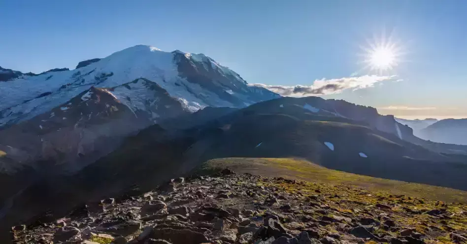
Burroughs Mountain Trail is one of the best hikes in the USA and was named as a mountain against a mountain. It is found at the northeastern face of Mount Rainier, enveloping the Winthrop Glacier. The trail features a nine-mile strenuous round trip over 7800 feet high. This trail is tough on the legs.
The amazing summit, the highest point accessible by foot in the entire park, is broad and barren. There are loads of great spots and dramatic glaciers on this trail. You’ll also have views of Washington’s largest volcano and numerous wildflower varieties, which have their floral display in early summer.
Wildlife atop the summit and goats are found at the hillsides. Chipmunks, marmots, and pika skitter wander among rocks, along the trail, or at the top of each three peaks.
Burroughs Mountain Trail is divided into three sections, the First Burroughs, The Second Burroughs, and the Third Burroughs. You’ll be given trail access from the northwest corner of the Sunrise parking lot.
The trail starts at the First Burroughs. The hike through the First Burroughs gains 400 feet uphill in just half a mile of the hike. Note that there can still be snowfields during the early summer, so precautions must be taken since you’ll be in for a steep snow trip.
On the Second Burroughs, you’ll gain additional 400 feet elevation after a half-mile hike. This trail offers impressive views of the Glacier Basin, Pointed Little Tahoma, Fremont Lookout, and the Berkeley and Grand Parks.
There is a nine-mile hike up to the Third Burroughs with 1,155 feet additional elevation gain. Here you’ll see plenty of big flat rocks and stunning views of Winthrop Glacier, Inter Glacier, and Camp Schurman.
Always be cautious, as there can be huge snowdrifts in earlier seasons.
6. South Rim Trail, Grand Canyon National Park
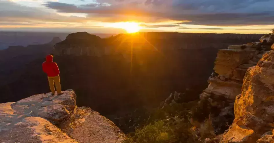
The South Rim of the Grand Canyon has an ample amount of hiking trails, approximately 13 miles in total. The challenging trails feature some narrow and exposed sections, not for everyone, especially beginners.
The most popular hike in the park is generally a flat trail with various dirt and paved trails, connecting Grand Canyon Village with Hermits Rest Point. It is the most picturesque section of the Grand Canyon. The South Rim Trail is best experienced during the spring and fall, avoiding the summer season.
South Rim’s first leg of the hike is the steepest uphill section of the trail. This part gives views of the Bright Angel Trail. It is a short but difficult hike, and you can just take the bus if you get tired.
In the middle section of the trail, some points hug the very edge of the Canyon rim. This is also where you’ll have full panoramic views of the Grand Canyon, the raging Colorado River, and the Whitewater rapids.
The final two legs of the trail are paved ways, excellent for bringing your young ones in their strollers. The last stop is the Hermits Rest which offers amazing views of the Grand Canyon and has a small snack bar and gift shop for souvenirs.
South Rim is loved by tourists because of its proximity to upscale hotels and lauded restaurants that offer visitors fun cultural experiences. The difficult-rated trail is open all year round. You’ll have a choice to either hike or hop on the bus throughout the hike.
7. Highline Trails, Glacier National Park
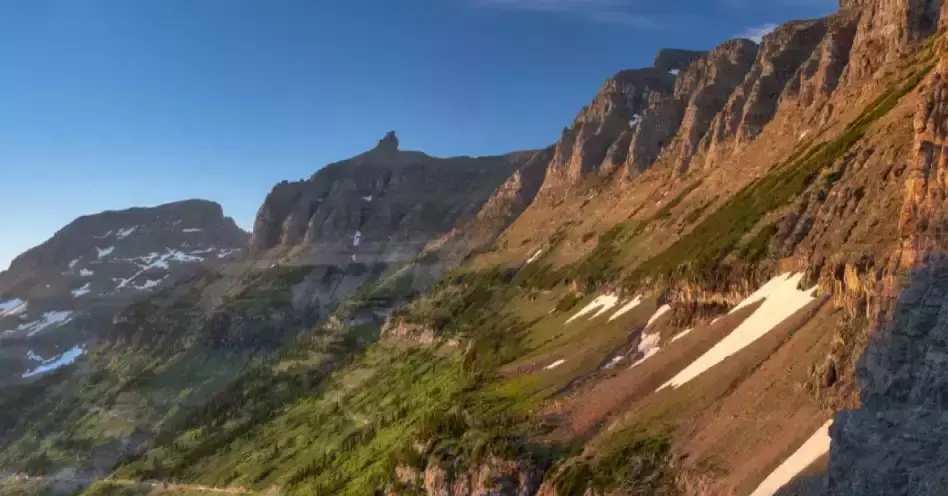
Highline Trails is one of the best hikes in Glacier National Park, located across the Going-to-the-Sun Road from the Logan Pass Visitors Center. The 7.5 miles trail starts from the Logan Pass and ends at the Granite Park Chalet, having mostly flat and fairly mild terrain for hiking, camping, and backpacking.
Along the trail, you’ll catch the famous garden wall, best visited during the spring and early summer. From June until October, you’ll experience wildflowers at their peak and a lot of wildlife like bighorn sheep, mountain goats, and grizzly bears, along with the wonderful views on the whole trail.
There are several ways to hike the Highline Trail. First is starting at the Logan Pass Visitors Center, then hiking one way to the Loop Trailhead, which requires a shuttle back to the Logan Pass Visitors Center.
Another way is to start at the Loop Trailhead, hiking one way to the Logan Pass Visitors Center or out-and-back to the Granite Park Chalet. You may also want to try the popular route of out-and-back hiking from Logan Pass Visitors Center to Granite Park Chalet.
Highline Trails is not an exceptionally difficult hike but is a very long route with narrow sections and steep drop-offs.
8. Mist Trail, Yosemite National Park, California
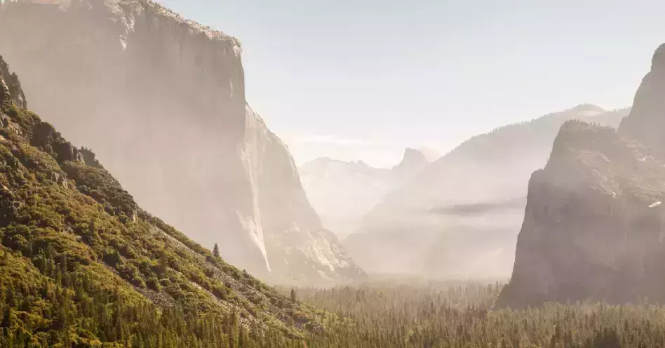
Another famous best hike in the US is Yosemite’s signature hike, the Mist Trail. Have a chance to stroll among the towering ancient redwood trees and see Vernal and Nevada Falls with this amazing hiking experience.
Scattered scenic views are found along the trail like the Bridge overlook, Liberty Cap, and the back of the Half Dome. The 3-mile hike is a round trip to Vernal Falls, with 1,000 feet elevation gain at the top.
The 7-mile hike to Nevada Falls has 1,900 feet elevation gain. You’ll hike an additional 1.5 miles if you walk rather than catching a shuttle bus to the trailhead, which has a 4,000 feet elevation gain.
Mist trail is best experienced from April to June. The trail is a moderate to difficult hike if you go all the way to the top of Nevada Falls. Furthermore, the stretches beside Vernal and Nevada Falls are a bit steep and would take about two to five hours to finish hiking.
9. Mount Rogers, Virginia
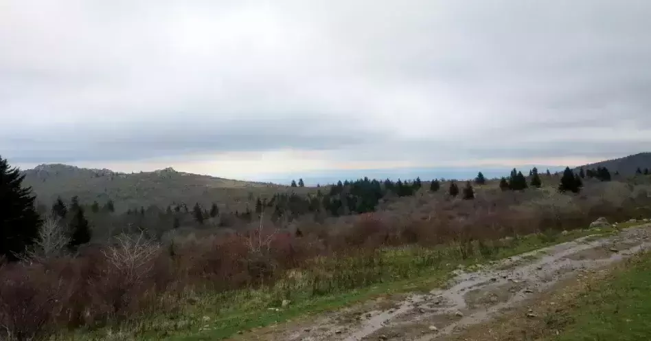
Mount Rogers is Virginia’s highest peak standing at 5,728 feet in the southwestern Blue Ridge Mountains, situated near the North Carolina border. It is one of the most interesting hikes in the state, with an approximately nine miles out-and-back hike.
The trail starts at Massie Gap in Grayson Highlands State Park, hiking 4.5 miles up and following the Appalachian Trail. The summit is covered with dense spruce-fir forest, and wild ponies roam at the mountaintop meadows. You can see rugged pastures, but wide-open views are rare.
Mount Rogers trail features spectacular views of the surrounding George Washington, like the Jefferson National Forest and large beds of wild blueberries and wildflowers. Feral highland ponies roam in the area.
More than 400 miles of the trail makes Mount Rogers, and the two best known are the Appalachian Trail and the Virginia Creeper Trail. The trails consist of primitive dirt footpaths, old logging roads, and railroad grades. Some trails allow horses and bicycles.
Besides hiking, biking and horseback riding are also popular in this area. The Grayson Highlands State Park, bordering Mount Rogers National Recreation Park to the south, offers nine hiking trails, welcoming panoramic vistas, scenic waterfalls, and a 200-year-old pioneer cabin.
This trail is moderate and is more on the enjoyable side. The long and challenging trail requires planning and stamina, but nothing as serious as advanced hikers do.
10. Halema’uma’u Trail, Hawai’i Volcanoes National Park
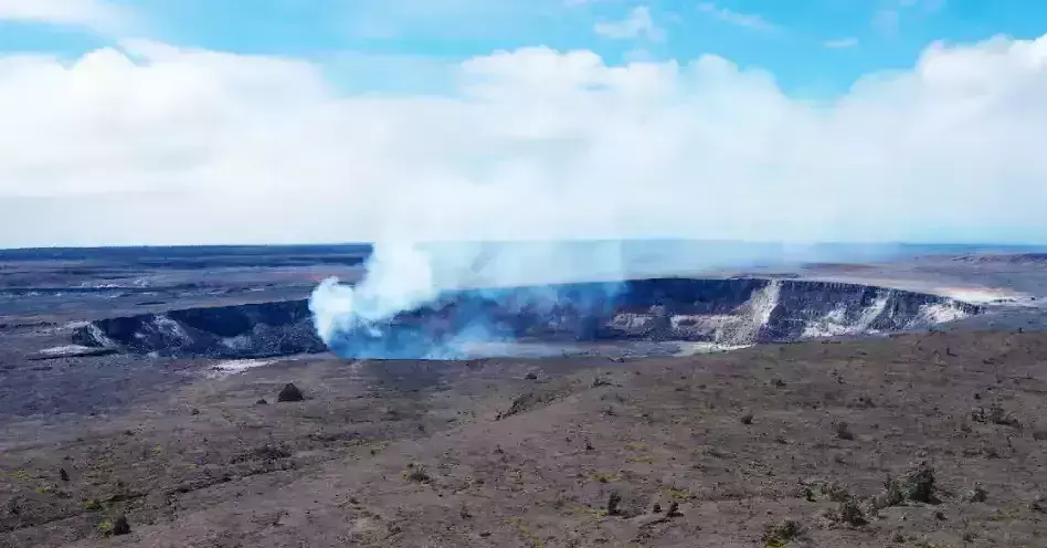
Halema’uma’u Trail in Hawai’i Volcanoes National Park is a 2.7-mile hike descending 425 feet at the southern edge of Kīlauea Caldera. The path leads through a rain forest to the heart of the world’s most active volcanoes.
This interesting trail gives you up close and personal experience of the heat of volcanoes in the park. Other famous trails in this park are the Earthquake Trail and the Waldron Ledge.
Stunning wildflowers and various plants grow along the trail like the hapu’u and ama’u ferns, Himalayan yellow ginger, and a variety of birds like apapane and yellow amakihi. Native Hawaiian plants and animals like faya or fire trees are also found along the trail.
Witness the steam coming from the rainwater touching the hot rocks of the volcano at the summit and a view of birds circling the area.
The route starts at Crater Rim Trail behind the Volcano House and ends at the Kīlauea Caldera Floor. This trail is rated moderate by hikers as you can finish it in one to one and a half hours hike round trip.
You may enjoy this trail any time of the year. Note that the Caldera floor trail is closed beyond Stop 10 due to high levels of sulphur dioxide gas, which may harm tourists and the current explosive nature of the volcano.
11. Navajo Loop Trail, Bryce Canyon National Park, Utah
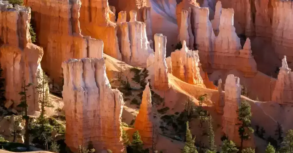
Navajo Loop Trail is one of the popular trails in Bryce Canyon National Park with 157 meters elevation gain. It is an under two miles round trip trail featuring a short and easy-to-walk trail, perfect for family and friends hiking.
The trail is known for hiking and nature trips offering gorgeous desert sceneries and is best visited from June to October. Trailhead starts across Sunset Campground, passing through Wall Street, a narrow switch-backed slot canyon between sheer cliffs.
You’ll be greeted by towering rock formations and the desert climate of the Navajo Loop Trail. Towering Douglas fir trees line up along the trail, and the outstanding Thor’s Hammer view is not to be missed.
The tall and narrow pinnacle with a narrower neck supporting a large hammerhead rock is the most photographed scenery in this trail. The west of the trail has perfect views of the Silent City and rock structures resembling towers, buildings, and temples. The east of the trail features the Temple of Osiris.
Navajo Loop Trail is rated moderate as most hikers finish the loop at one to two hours.
12. Canyon to Rim Loop, Smith Rock State Park
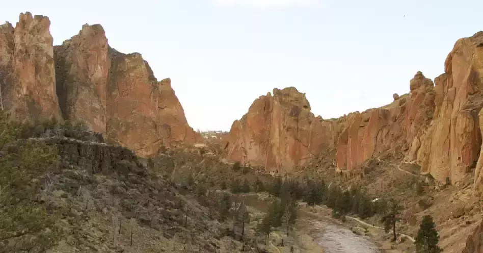
Canyon to Rim Loop in Smith Rock State Park is a 3.4 miles roundtrip hike starting at the Welcome Center, going down the paved path, the gravel road, and a hike along the gentle Canyon Trail.
There are various things to see in this trail, like sightings of geese and ducks on riverbanks, blue heron perched on a rock near the river, some lucky sighting of a cougar, and climbers along Rope-de-Dope.
The trail also offers amazing Canyon views, wildlife along the Crooked River, dense vegetation, cave rocks in the park, and bald eagles nesting along the rim. The hike in this trail is rated easy to moderately difficult.
13. Superior Hiking Trail, Minnesota
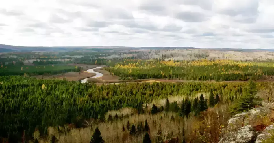
Midwest’s most epic hike, the Superior Hiking Trail at Minnesota, hugs Lake Superior ridgeline 296 miles from Duluth to the Canadian border. It sits 1000 feet above the lake, going down into forested river valleys with moose, bear, and beaver sightings.
The trail is built, maintained, and managed by Superior Hiking Trail Association (SHTA), a private nonprofit organization in Two Harbors, Minnesota. The rugged and challenging footpath is perfect for day hikes, backpacking, thru-hike trips, and trail running.
Superior Hiking Trail blooms with maples during the fall and wild berries in the summer. Mesmerizing overlooks of waterfalls, boreal forests, and wildlife are also not to be missed.
The trail can be accessed in over 50 trailheads inside state parks along North Shore, in the City of Duluth, or along Hwy 61 from the west of Two Harbors to the North of Grand Maris.
A hike in this trail is rated easy to moderate. The 300 plus miles rugged footpath requires appropriate planning and gear. The 18-mile stretch from Silver Bay to Country Route 6 passes several small lakes, birch groves, and cliffs. You’ll have a Superior panoramic view throughout the trail.
No fees or permits are required to hike in this trail; only Minnesota State Park passes for parking in state parks.
14. Penobscot and Sargent Mountain Loop, Maine
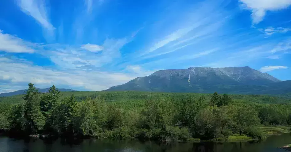
Penobscot and Sargent Mountain Loop’s nine-kilometer trail near Mount Desert is the most rewarding hike in Acadia National Park. It consists of two summits, rocky scrambles and crystal clear ponds.
Penobscot and Sargent Mountain Loop trail is perfect for hiking, nature trips, and bird watching. It provides a view of Mount Desert Island, the iconic view of Bubbles island, and the crystal clear water of Jordan Pond.
You’ll encounter wild Maine blueberries along the route, and the views at the peak are worth every sweat. Dogs are allowed to join the hike so long as they are on a leash.
The entire route is a five-mile hike, traveling one and a half miles from the start of the Spring Trail to the Peak of Penobscot, a mile to Sargent, another mile down to Jordan Pond, and one and a half miles back to Jordan Pond House. The destination distance from downtown is about 109.6 miles.
It is an easy to moderate trail. The climb up the Spring Trail and Sargent is steep, and descents and wet days should be avoided. Caution should always be observed for beginner hikers.
You would spend about three hours to complete the loop trail, which is best visited during the summer months and early fall. The elevation gains up Penobscot Mountain is 940 feet and 360 feet additional up on Sargent Mountain.
15. Charlies Bunion Hike, Great Smoky Mountains National Park
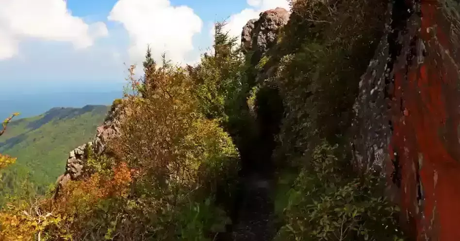
Charlies Bunion Hike at Great Smoky Mountains National Park is a world-renowned trail that houses a diversity of plants and animals, offering various mountains to hike.
The trail starts through the Appalachian Trail, then a four-mile one-way hike to Charlies Bunion. Here you’ll find the picturesque stone outcrop known as Charlies Bunion, which was naturally created many years ago by fire, rain, and subsequent landslide.
Charlies Bunion Hike features magnificent views of mountains, valleys, and beautiful wildflowers. Witness the panoramic views of the Great Smoky Mountains at the 1.7-mile intersection of Sweat Heifer Creek Trail junction, the highest section of the trail, a dense alpine forest.
This trail’s route travels across multiple peaks of Mount Ambler, Mount Kephart, and Masa Knob, terminating at Charlies Bunion. It starts at a gradual climb of about 300 feet for the first mile, which features a forested trail for most of the hike and a few viewpoints of the Ice Water Spring-AT shelter, then continues a mile north of the shelter.
The trail is rated moderate, which requires a three to four hours out-and-back hike to finish and an elevation change of 1,600 feet. The firm-packed trail travels across exposed cliffs and is best experienced from April to October.
Conclusion
Hiking is always number one on the list of adventurous outdoor activities, and these best hikes in the US will never disappoint you. These trails are perfect for any level of hiker, be it beginner or advanced level. Be prepared as you will not only be training your legs in these hikes, but your eyes will be full with all the stunning views you’ll encounter during each hike.


